Access Data
Compression Directions in Southern California
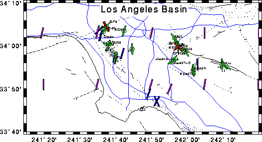
Map of Los Angeles Area Only
Map of Los Angeles Basin in the region T3S to T1S and R9W to R14W, showing circles at the locations of drill holes used in this study. Color lines plotted through the circles indicate the inferred direction of SHmax (greatest horizontal principal stress) at each location studied. Green lines indicate borehole elongation directions which we believe are the result of true breakouts. Red lines indicate borehole elongation directions felt to be the result of key seats or tool drag in the holes, which are not felt to be reliable indicators of the SHmax direction. Blue lines show data from other studies of borehole breakouts [Suppe, 1992; Zoback, 1992; and Kerkela, 1996]. Purple lines show data from focal mechanism studies [Hauksson, 1990; and Zoback, 1992].