Access Data
Compression Directions in Southern California
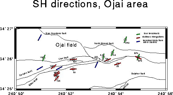
Map of Upper Ojai Valley
Map of Upper Ojai Valley area in the region T4N, R21W to R22W, showing circles at the locations of drill holes used in this study. Color lines plotted through the circles indicate the inferred direction of SHmax (greatest horizontal principal stress) indicated by borehole elongations at each location studied. Green lines indicate boreholes for which we consider the elongation data to be relilable (breakouts); red lines are those boreholes for which the elongation data are probably the result of key-seats in the borehole and do not reliably indicate the stress direction. The reliable data provide a very consistent direction of SH of N20E. Blue lines show data from other studies of borehole breakouts [Zoback, 1992].