Earthquake Information
Chronological Earthquake Index
San Jacinto Earthquake
TYPE OF FAULTING: right-lateral strike-slip
FAULT INVOLVED: San Jacinto fault
TIME: April 21, 1918 / 3:32 pm, PDT
LOCATION: 33° 45' N, 116° 53' W near the town of San Jacinto about 112 km (70 miles) ESE of Los Angeles
MAGNITUDE: roughly ML6.8
While the damage caused by the San Jacinto earthquake of 1918 was high, its timing was fortunate, and kept the number of fatalities and injuries low. Most of the damage caused by the quake occurred in the business districts of the towns of San Jacinto and Hemet, where large masonry structures collapsed in the shaking. Luckily, the quake struck on a Sunday afternoon, when the business districts were empty. Still, as it was, several people were injured and one death was reported. Two miners were trapped in a mine near Winchester, but were eventually rescued, uninjured. In another display of amazingly good fortune, two men in an automobile were swept off a road by a landslide, and would have rolled several hundred feet down a hillside had they not been stopped by a large tree, before they had moved far very off the road at all.
The shaking cracked the ground, concrete roads, and concrete irrigating canals, but none of the cracks left behind were thought to represent actually surface rupture, though in one place, the alignment of a road was said to be off by about 7.5 centimeters (3 inches). Landslides, as mentioned above, were triggered, and the road from Hemet to Idyllwild was blocked in several places. Huge boulders rolled down nearby slopes. The flow rates of several springs in the area were altered, and it is claimed that the temperature of nearby hot springs changed. Sand craters were formed on one farm, and an area near Blackburn Ranch seemed to have "sunk" roughly one meter during the quake.
The earthquake caused minor damage outside the San Jacinto area, as well, and was felt as far away as Taft (west of Bakersfield), Seligman (Arizona), and Baja California.
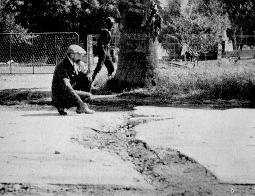
Crack formed in a concrete road, 1.6 km (1 mile) north of San Jacinto. (Photo: Frank Rolfe)
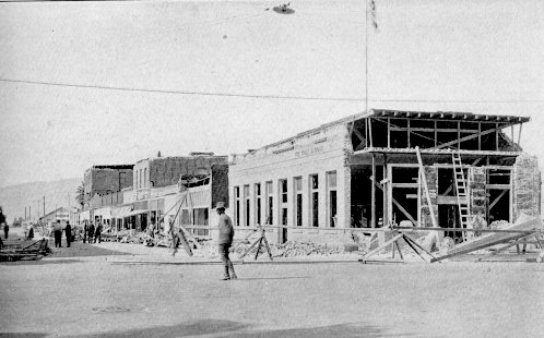
The First National Bank, and other damaged buildings, in Hemet. (Photo: Sidney D. Townley)