Earthquake Information
Earthquake Preparedness
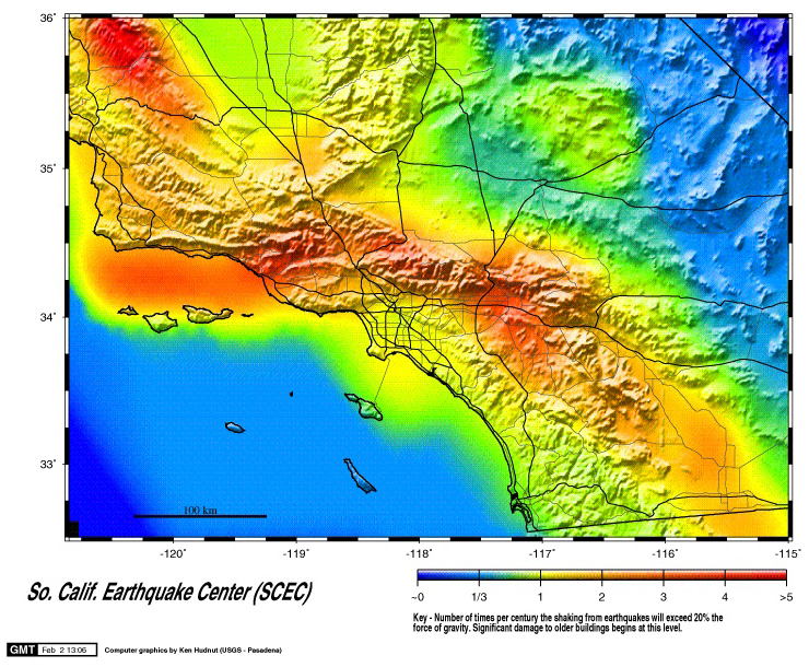
Seismic Hazards Map for Southern California
Probable Earthquakes 1994-2024
This analysis predicts that somewhere in southern California (not everywhere-many residents would not be affected) should experience a magnitude 7.0 or greater earthquake about seven times each century. About half of these will be on the San Andreas "system" (the San Andreas, San Jacinto, Imperial, and Elsinore Faults) and half will be on other faults. The equivalent probability in the next 30 years is 85%.
Caveat
This map does not include site effects. The tabulation of soil conditions for all of southern California is not yet completed. This map shows the rate of shaking, as if everywhere were on solid rock. Another project in progress will update this map by showing a higher level of shaking for soft-soil sites. This will lead to a higher rate of damaging shaking because the more common smaller earthquakes will produce greater shaking in soft soil. The result will be to increase slightly the rates for the sedimentary basins such as the Los Angeles basin and the San Gabriel, Ventura and San Bernardino Valleys.
Map Availability
The Earthquake Hazard Analysis Map can be retrieved from our anonymous ftp site and is available in the following three formats: postscript, JPEG, and GIF.
Reference
The complete hazard analysis is published in:
- Working Group on California Earthquake Probabilities, 1995
- Seismic Hazards in Southern California: Probable Earthquakes, 1994-2024
- Bulletin of the Seismological Society of America, Vol.85, No. 2, pp. 379-439.
- Seismic Hazards in Southern California: Probable Earthquakes, 1994 to 2024
- Reprints of this report are available from the Southern California Earthquake Center
Other Links