Earthquake Information
Chronological Earthquake Index
Volcano Lake Earthquake
TYPE OF FAULTING: uncertain; probably right-lateral strike-slip
TIME: November 29, 1852 / about noon
LOCATION: 32° 25' N, 115° 00' W about 48 km (30 miles) southwest of Yuma, Arizona
MAGNITUED: ML6.5
A shock with obvious indicators of geologic activity, the 1852 Volcano Lake earthquake formed cracks in the clay desert near the Colorado River, and caused mud volcanos and geysers to become active southwest of Fort Yuma, near Volcano Lake, Mexico, where the epicenter presumably was located. Shaking near Fort Yuma was quite strong, and part of Chimney Peak was thrown down. Shaking was felt in San Diego, lasting perhaps a minute or two. The quake was felt as far away as Guaymas, in Sonora, Mexico.
It is possible that a series of strong shocks was felt across southern California in November of 1852, from Baja California to San Luis Obispo, but the relation between these earthquakes (if indeed there were several strong shocks) is unknown.
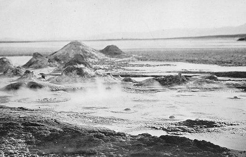
Mud volcanoes on the west side of Volcano Lake, similar to those which erupted after the 1852 earthquake. (Photo: D.T. MacDougal)