Access Data
Special Data Sets
Real Time GPS displacement waveforms provided by the AIST project
Background
Under the NASA funded Advanced Information System Technologies program (AIST), real time GPS total displacement waveforms from the California Real TimeNetwork (CRTN) are being converted into seismic formats as displacement seismograms and archived at the SCEDC. One the key goals of this project, entitled Real-Time In Situ Measurements for Earthquake Early Warning and Spaceborne Deformation Measurement Mission Support, is to promote the integration of these data into the scientific seismic analysis that is conducted using data at the SCEDC.
The plan is to have these data available in near real time, and permanently archive them at the SCEDC. In doing so, the project pays special attention to the different needs and data product drivers of the geodetic and seismological communities, and is aiming to produce new geodetic products that can be easily assimilated into routine data analysis by both seismologists and geodesists. Samples of a synthetic version of these data were released with the 2008 ShakeOut scenario data last year.
Dataset Description
Three component 1Hz seismograms of CRTN GPS stations, from the April 4, 2010, magnitude 7.2 El Mayor-Cucapah earthquake are available in SAC format (2 MB) at the SCEDC. These time series were created by Brendan Crowell, Yehuda Bock, the project PI, and Mindy Squibb at SOPAC using data from the CRTN and the methodology described in Crowell et al. (2009), and references therein. The El Mayor-Cucapah earthquake demonstrated definitively the power of real-time high-rate GPS data: they measure dynamic displacements directly, they do not clip and they are also able to detect the permanent (coseismic) surface deformation.
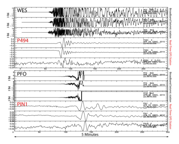
Figure 1. Broadband Seismic vs GPS waveforms from co-located stations. GPS waveforms do not clip.
In the inversion CRTN high-rate positions are determined relative to a station far from the epicenter. In addition to the unclipped seismic displacements from the earthquake, this results in arrivals that appear simultaneous across all stations caused by translation of the entire network relative to the fixed station. Although the artifacts for this earthquake are well within the noise of the GPS displacements, the project is researching ways to minimize them.
Downloads
A plot of the data, a plot of the station locations, an ASCII file of station locations, and a tar-file of the data in SAC-format are the package being distributed. Acknowledgments and Citations: An appropriate acknowledgment for the use of these data is GPS displacement waveforms are a product of the National Aeronautics and Space Administration (NASA) AIST project, Grant No. NNX09AI67G. An appropriate scientific citation is Crowell et al. (2009) below.
Crowell, B., Y. Bock, and M. Squibb (2009), Demonstration of earthquake early warning using total displacement waveforms from real time GPS networks, Seismo. Res. Lett., 80(5), 772-782, doi: 10.1785/gssrl.80.5.772.
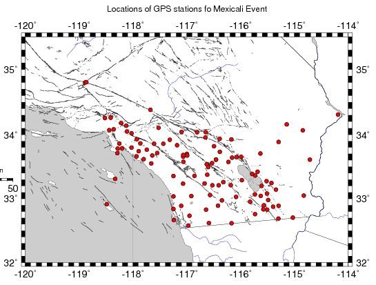
Figure 2. Map of the stations in the GPS stations in the data set. The stations are part of the California Real Time Network (CRTN). Download coordinates.
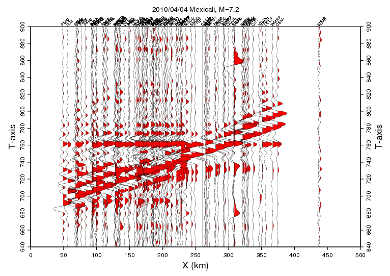
Figure 3. Plot of the traces. The time starts at 2010/04/04,23:30:00. The traces are indiviually scaled and have been filter with a passband from 100 sec to 10 sec. The horizontal feature at 760 sec is an artifact due to a shift of the entire GPS network. The data are available as a tar of sac-files (2 MB).