Earthquake Information
Chronological Earthquake Index
Big Bear Earthquake
TYPE OF FAULTING: left-lateral strike-slip
TIME: June 28, 1992 / 8:05:30 am PDT
LOCATION: 34° 12' N, 116° 49.6' W 8 km (5 miles) SE of Big Bear Lake 40 km (25 miles) east of San Bernardino
MAGNITUDE: MS6.3
DEPTH: 5 km
While technically an "aftershock" of the Landers earthquake (indeed, the largest aftershock), the Big Bear earthquake occurred over 40 km west of the Landers rupture, on a fault with a different orientation and sense of slip than those involved in the main shock -- an orientation and slip which could be considered "conjugate" to the faults which slipped in the Landers rupture.
The Big Bear earthquake rupture did not break the surface; in fact, no surface trace of a fault with the proper orientation has been found in the area. However, the earthquake produced its own set of aftershocks, and from these, we know the fault geometry -- left-lateral slip on a northeast-trending fault.
Following the Landers mainshock by three hours (it occurred while TV news coverage of the Landers earthquake was being broadcast live from Caltech), the Big Bear earthquake caused a substantial amount of damage in the Big Bear area, but fortunately claimed no lives. Landslides triggered by the jolt blocked roads in the San Bernardino Mountains, however, aggravating the clean-up and rebuilding process.
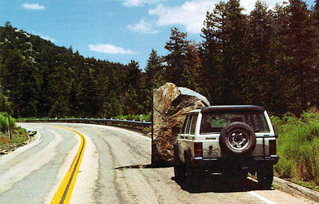
This vehicle-sized boulder was shaken down onto Highway 38 east of Barton
Flats by the Big Bear earthquake. (Note the hole in the pavement just to its left.)
(Photo: Jeff Knott, CALTRANS)