Earthquake Information
Glossary
aftershock
Any earthquake which occurs after a larger earthquake (a mainshock) within one rupture-length of the original fault rupture and before the seismicity rate in that area has returned to the background (pre-mainshock) level is generally considered an aftershock. For some earthquakes, a specific "aftershock zone" may be defined, in lieu of the one-rupture-length rule given above.
afterslip
Aseismic slip, very similar to creep, that occurs along a fault ruptured by a large earthquake in the months following that event.
alluvium
Loose material -- clay, silt, sand, gravel, and larger rocks -- washed down from hills and mountains and deposited in low areas.
Alquist-Priolo Act
Zoning act passed in 1972 -- in response to the 1971 San Fernando earthquake to prevent building across the traces of active faults.
More information about the Alquist-Priolo Act, and Earthquake Fault Zone Maps is available from the California Geological Survey.
Basin and Range
An area of the southwestern United States characterized by roughly parallel mountain ranges and valleys, formed by a series of tilted fault blocks, and brought about by tectonic extension of the region. As is true of any region experiencing crustal extension, normal faulting is common here. (This name can apply generally to any zone of similar landforms and tectonics.)
blind thrust fault
A shallow-dipping reverse fault which terminates before it reaches the surface. When it breaks, therefore, it may produce uplift, but never any clear surface rupture. Many still-unknown blind thrust faults may exist in southern California. Two examples of known blind thrust faults: the Elysian Park Thrust, which runs underneath downtown Los Angeles and the Northridge Thrust Fault, which ruptured in the 1994 Northridge quake.
conjugate (faults)
Describes a pair of intersecting (or nearly intersecting) faults, the slip motions of which are opposite (e.g., right-lateral and left-lateral), so as to accomodate the rotation of the block they bound. Conjugate faults will sometimes slip roughly "simultaneously" (within hours or days of each other), causing pairs of earthquakes. One example of this is the 1987 Elmore Ranch/Superstition Hills earthquakes, in which the rupture of the left-lateral Elmore Ranch fault was followed only a day later by the rupture of the right-lateral Superstition Hills fault. The 1992 Landers and Big Bear earthquakes were also a conjugate pair.
creep
Relatively slow, quiet movement along a fault. It is sometimes called "seismic creep" to distinguish it from the slumping of rock or soil on slopes (which is also known as creep), and sometimes called "aseismic creep", since it does not trigger events greater than microearthquakes.
decollement
A detachment fault; a fault where crustal deformation causes separation along a boundary of rock types, typically between so-called crystalline "basement" rock and overlying sedimentary rocks.
dip
The angle between a geologic surface -- for example, a fault plane -- and the horizontal. The direction of dip can be thought of as the direction a ball, if placed upon the tilted surface, would roll. Thus, a ball placed on a north-dipping fault plane would roll northward. The dip of a surface is always perpendicular to the strike of that surface.
dip slip
Fault movement (slip) that is parallel to the dip of the fault. This can describe both normal slip and reverse slip.
Eastern California Shear Zone (ECSZ)
A region of increased seismic activity which stretches from the San Andreas fault near Indio, north-northeast across the Mojave and northward into Owens Valley. It may accommodate as much as 10 to 20 percent of the relative motion between the North American and Pacific plates.
epicenter
The point on the Earth's surface directly above the (subterranean) point of origin (hypocenter) of an earthquake; only two measurements, latitude and longitude, are needed to locate it.
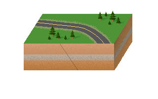
fault
A fracture or zone of fractures along which there has been displacement of the sides relative to one another, parallel to the fracture.
fault line
A commonly-used term that is synonymous with the surface trace of a fault. It should never be used to describe the fault itself; faults are planar, not linear, features.
fault strand
An individual fault of a set of closely-spaced parallel or subparallel faults of a fault system.
focal mechanism
The direction and sense of slip on a fault plane at the point of origin (hypocenter) of an earthquake, as inferred from the first seismic waves which arrive at various locations; often, they are draw on maps with a "beachball"-like symbol:  . The black areas denote compression; the white areas denote dilation. The fault plane which moved is parallel to one of the two planes dividing the sphere in half.
focus
see hypocenter
footwall
Of the two sides of a non-vertical fault, the side below the fault plane. It is called the footwall because where inactive faults have been "filled in" with mineral deposits and then mined, this is the side on which miners walk. (See hanging wall.)
foreshock
Any earthquake which is followed, within a short time span, by a larger earthquake in the exact same location can be labelled a "foreshock". (In the case of an earthquake swarm, this terminology is not generally applied.)
graben
An elongate part of the Earth's crust bounded by faults on its long sides and relatively down-dropped compared to its surroundings.
hanging wall
Of the two sides of a fault, the side above the fault plane. It is called the hanging wall because where inactive faults have been "filled in" with mineral deposits and then mined, this is the side on which miners can hang their lanterns. (See footwall.)
horizontal fault
A fault with no dip. Still theoretical, this sort of fault should only exist within a region of strong compression or extension where the tectonic forces required for such movement could be present.
Holocene
The most recent geologic era; from about 10,000 years ago to the present. The Holocene is the latest epoch of the Quaternary period.
hypocenter
Also known as the focus, the hypocenter is the point of origin of an earthquake. It can be expressed with no fewer than three measurements: latitude, longitude, and depth.
intensity
A measure of the effects at a particular place produced by shaking during an earthquake. (Not to be confused with magnitude.)
isoseismal map
A map showing the distribution of intensity across a region for a particular earthquake using isoseismal lines to connect points of equal intensity.
isoseisms (or isoseismal lines)
A line connecting points of identical intensity for a given earthquake.
lateral fault
A fault in which slips in such a way that the two sides move with a predominantly lateral motion (with respect to each other). There are two kinds of lateral slip: right-lateral and left-lateral. They can be distinguished by standing on one side of the fault, facing the fault (and, of course, the other side), and noting which way the objects across the fault have moved with respect to you. If they have moved to your right, the fault is right-lateral. If the motion is to the left, then the fault is left-lateral.
View an animation of left-lateral slip (50 K) or right-lateral slip (50 K).
magnitude
A general term for a measure of the strength or energy of an earthquake as determined from seismographic information.
ML (local magnitude)
A measure of the strain energy released by an earthquake within 100 kilometers of its epicenter. Strictly defined by Charles Richter as the base-10 logarithm of the amplitude, in microns, of the largest trace deflection that would be observed on a standard torsion seismograph at a distance of 100 km from the epicenter.
Ms (surface-wave magnitude)
A magntiude determined at teleseismic distances using the logarithm of the amplitude of 20-second period surface waves generated by an earthquake.
Mw (moment magnitude)
The seismic moment of an earthquake, converted to a magnitude scale that roughly parallels the original Richter magnitude scale. However, since it is not based on the same measurements as Richter (local or surface-wave) magnitudes, the different magnitudes do not always agree, particularly for very large quakes. Because it relates directly to the energy released by an earthquake, it has become the standard in modern seismology.
mainshock
The largest earthquake in any series of earthquakes; to be definitively called a "mainshock", it should generally be at least half a magnitude unit larger than the next largest quake in the series. Otherwise, the series of quakes may more accurately fit the definition of a swarm.
microearthquake
A term used to describe earthquakes under Richter magnitude 2, and occasionally, slightly larger quakes, especially those not felt by people nearby.
Modified Mercalli Intensity Scale
An earthquake intensity scale adopted in 1931 that divides the effects of an earthquake into twelve categories, from I (not felt by people) to XII (damage total). A full listing of the scale is available.
Mojave Block
The tectonic region located between the Garlock fault and the San Andreas fault, and extending eastward roughly to the California-Arizona (and California-Nevada) border.
normal fault
A fault characterized by predominantly vertical displacement in which the hanging wall is moved downward with respect to the footwall of the fault. Generally, this kind of fault is a sign of tectonic extension.
View an animation of normal slip (84 K).
oblique (fault or slip)
Describing motion that is a combination of movement both perpendicular and parallel to the strike of a fault -- a combination of strike-slip and dip-slip (whether normal or reverse).
View an animation of oblique slip (89 K).
playa
A term used primarily in the southwestern United States to describe a dry, vegetation-free, flat area at the lowest part of an undrained desert basin, underlain by stratified clay, silt, or sand, and commonly by soluble salts. They are occasionally covered by shallow lakes in the wettest parts of the year.
Pleistocene
A name given to the geologic time period between about 1.6 million years and 10,000 years before the present. The Pleistocene is the earlier (older) epoch of the Quaternary period; it is followed by the Holocene.
P-wave
The fastest of seismic waves, and thus the first to arrive at a location following an earthquake (the P stands for "primary"). This is a compressional body wave; particle movement is parallel to the direction of propagation of the wave. Its speed is 5.5 to 7.2 km/sec in the crust and 7.8 to 8.5 km/sec in the upper mantle.
Quaternary
The period of geologic time starting 1.6 million years ago and continuing to the present day. It is divided into two epochs: the Pleistocene and the Holocene, with the division between these two falling at about 10,000 years before the present.
Late Quaternary refers to the time between 700,000 years ago and the present day. It does not necessarily exclude the Holocene epoch.
Pre-Quaternary refers to any time before 1.6 million years ago.
reverse fault
A fault in which the displacement is predominantly vertical, and the hanging wall is moved upward with respect to the footwall. Some amount of reverse slip is often seen in predominantly lateral faults.
If a reverse fault has a dip angle of less than 45 degrees, it is called a thrust fault.
View an animation of reverse slip (67 K).
Richter scale
Introduced in 1935 by Charles F. Richter, the Richter scale is a numerical scale for quantifying earthquake magnitude -- typically it refers to local magnitude, but for larger quakes, it often refers to surface-wave magnitude. (Currently, large quakes are generally assigned a moment magnitude, which is scaled to be similar, but is based on seismic moment, and a better measure of the energy of an earthquake.) Since the Richter scale is logarithmic, very small earthquakes (microearthquakes) can have a negative magnitudes. While the scale has no theoretical upper limit, the practical upper limit, given the strength of materials in the crust, is just below 9 for local or surface-wave magnitudes (and just below 10 for moment magnitudes
scarp
A roughly linear, cliff-like slope or face that breaks the continuity of a surface into distinct levels. Scarps are often produced by faulting, especially that which involves a significant amount of dip slip.
seismic creep
See creep.
seismic gap
A segment of an active fault zone that has not experienced a major earthquake during a time interval when most other segments of the zone have. Seismologists commonly consider seismic gaps to have a high future-earthquake potential.
seismic moment
A measure of the strength of an earthquake, equal to the product of the force and the moment arm of the double-couple system of forces that produces ground displacements equivalent to that produced by the actual earthquake slip. It is also equal to the product of the rigidity modulus of the Earth material, the fault surface area, and the average slip along the fault. Therefore, both seismological and geological observations can produce the same result.
seismic zone (or seismic belt)
A region of the Earth's crust, generally linear, associated with active seismicity. It may not necessarily be connected with a particular fault or surface fault trace.
sense of slip
The sense with which one side of a fault slips relative to the other side, in a reference frame defined by a horizontal (level) plane oriented with the pull of Earth's gravity pointed "down" (perpendicular to the plane).
slip rate
The relative speed with which the two sides of a fault move past each other. Typically, slip rates are measured in millimeters per year. This figure applies to the motion of a fault over an extended period of time, since most faults slip only during earthquakes; in between earthquakes, the two sides are "locked." Thus, a slip rate of 6 mm/yr does not mean that two structures built directly across from each other on either side of a fault will move past each other at 0.5 millimeters per month, 6 millimeters per year, or 60 millimeters per decade. They may, for example, remain relatively "fixed" for many years until they are suddenly offset several meters in a large earthquake.
strike
The direction, or trend, of the line marking the intersection of a fault plane (or another planar geologic feature) with the horizontal. Strike is always at a right angle to dip.
strike-slip fault
A fault along which the slip motion is parallel to the strike of the fault.
surface rupture
The breakage of ground along the surface trace of a fault caused by the intersection of the fault surface area ruptured in an earthquake with the Earth's surface.
surface trace
The intersection of a fault plane with the surface of the Earth. It is sometimes, but not always, expressed at the surface by geomorphic evidence (ridges, valleys, saddles, etc.).
swarm
A series of minor earthquakes, none of which may be identified as the mainshock, occurring in a limited area and time.
S-wave
A seismic body wave which propagates by a shearing motion; particle vibrate in a direction perpendicular to that of the propagation of the wave. Slower than the P-wave, the S-wave always arrives after the P-wave (the "S" stands for "secondary"). Its speed is roughly 3 to 4 km/sec in the crust and 4.4 to 4.6 km/sec in the upper mantle. Because of its shearing motion, it cannot propagate through liquids. The S-wave is responsible for our determination that the Earth's outer core is liquid, since S-waves cannot travel through the outer core.
teleseismic
An adjective to refer to earthquakes, and any properties thereof, that occur more than 100 km from a particular site. In this age of modern seismic data-recording networks, this translates to more than 100 km from the nearest operational station in that network.
thrust fault
A specific kind of reverse fault in which the dip of the fault is less than 45 degrees over much if not all of its length. It is characterized not so much by vertical displacement, but by horizontal compression. Thrust faults are an obvious sign of compressional tectonics.
View an animation of thrust fault motion (77 K).
Transverse Ranges
The mountains formed by compression associated with the Big Bend of the San Andreas fault zone -- primarily the San Gabriel and San Bernardino Mountains. They are called transverse because they stretch east-west, unlike the north-south trending Sierra Nevada, Peninsular Ranges, and the mountains of the Basin and Range province. Thus, they are transverse to most other California mountains and to the overall tectonic motion at this plate boundary.
triggered slip
A somewhat poorly understood process; involves the slipping of a fault located in the same region as, but not directly associated with, a fault which ruptures in a major earthquake. Most likely, the shaking of the ground during the earthquake causes minor slippage along temporarily "loosened" faults.