Earthquake Information
Chronological Earthquake Index
Ridgecrest Earthquake
Major Foreshock
TIME: August 17, 1995 / 3:39 pm PDT
LOCATION: 35° 46.6' N, 117° 39.7' W 11 miles (18 km) north of Ridgecrest
MAGNITUDE: ML5.4
DEPTH: 5.6 km
TYPE OF FAULTING: initially normal faulting; evolved quickly into right-lateral strike-slip
Mainshock
TYPE OF FAULTING: right-lateral strike-slip
TIME: September 20, 1995 / 4:28 pm PDT
LOCATION: 35° 45.6' N, 117° 38.3' W 10 miles (16 km) north of the town of Ridgecrest
MAGNITUDE: ML5.8
DEPTH: 5.4 km
The 1995 Ridgecrest earthquake sequence started on August 17, when a magnitude 5.4 quake, centered 18 kilometers north of the town of Ridgecrest, shook the area and spawned over 2,500 aftershocks over the course of the following five weeks. Then, on September 20, 1995, the second large quake struck the area. This one, centered 2 kilometers southeast of the August 17 shock -- probably on the same fault segment -- measured magnitude 5.8, was at that time the largest earthquake to hit southern California since the January 17, 1994, Northridge earthquake, and still is the largest earthquake ever recorded in the immediate area, though larger quakes are possible along some of the nearby fault zones.
Over 1,900 aftershocks were recorded in the first two weeks following the September 20 quake. Several thousand more aftershocks have been recorded in the area since then. Like previous earthquake activity in this area, the aftershocks showed some spatial migration, with activity being triggered both northeast and southeast of the original epicentral region. At least four small faults in the southern portion of the Airport Lake fault zone slipped in the course of the two main shocks and the larger aftershocks, and about 1 cm of surficial triggered right-oblique slip was seen on a 3-km-long fault segment roughly 3 km northwest of the epicentral area. No obvious surface rupture was found along the fault segment believed to have caused the two main shocks.
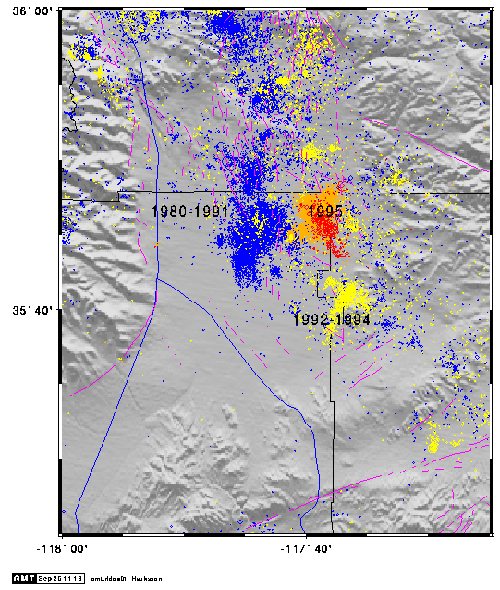
This area, which is associated with the Eastern California Shear Zone (ECSZ), has experienced numerous earthquake swarms in the past, groups of several thousand quakes under magnitude 5 or so, often with no obvious mainshock. These quakes are shown in the figure below along with the earthquakes in the 1995 Ridgecrest sequence. Blue lines represent highways, and purple lines represent fault traces. The thin black lines are the boundaries of counties.
1980 - 1995 Ridgecrest Earthquakes
1980-1991 (blue); 1992-1994 (yellow); 1995 (orange and red since 20 Sept.))
On November 27, 1996, a magnitude 5.3 quake struck the area near Coso Hot Springs, just north of the map above, followed by numerous aftershocks. This Coso earthquake sequence is yet another example of the kind of seismic activity which characterizes this region of California along the ECSZ.