Earthquake Information
Chronological Earthquake Index
San Jacinto Fault Zone
TYPE OF FAULTING: right-lateral strike-slip
FAULT INVOLVED: San Jacinto fault
TIME: December 25, 1899 / 4:25 am PST
LOCATION: near 33° 40' N, 116° 50' W roughly 16 km (10 miles) southeast of San Jacinto about 115 km (72 miles) ESE of Los Angeles
MAGNITUDE: roughly ML6.5 (?)
The epicenter of this earthquake was not well located, but the damage pattern suggests the epicenter shown on the map -- a location not far from the epicenter of the 1918 San Jacinto earthquake, itself located primarily by intensity isoseismals, which rely heavily on damage reports to construct. Since this method of locating quakes is difficult in sparsely populated areas (like southern California around the turn of the century), the locations of both epicenters are questionable. Regardless, this was a devastating earthquake. Damage was greatest in the towns of San Jacinto and Hemet, where nearly all brick buildings were reported to be either badly damaged or destroyed. Also hit hard was the Soboba Indian Reservation, where six people were killed by falling adobe walls. Chimneys were thrown down and walls cracked in Riverside. Other outlying areas reported minor damage.
The quake supposedly created several large "sinks" some 10 miles southeast of San Jacinto, though no actual surface rupture is known. This earthquake was followed by a sizable aftershock sequence -- thirty aftershocks were reported felt in the San Jacinto area on December 25 alone. The main shock was felt as far away as San Diego, Needles (then a railroad stop known as "the Needles") -- where it supposedly broke glass and stopped clocks -- and even Seligman, Arizona.
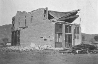
Damage typical of buildings in the towns of San Jacinto and Hemet.
This was the Pomengia Building in San Jacinto. The San Jacinto
Mountains can be seen in the distance. (Photo: E.W. Claypole)