Earthquake Information
Chronological Earthquake Index
Fort Tejon Earthquake
TYPE OF FAULTING: right-lateral strike-slip
TIME: January 9, 1857 / about 8:20 am PST
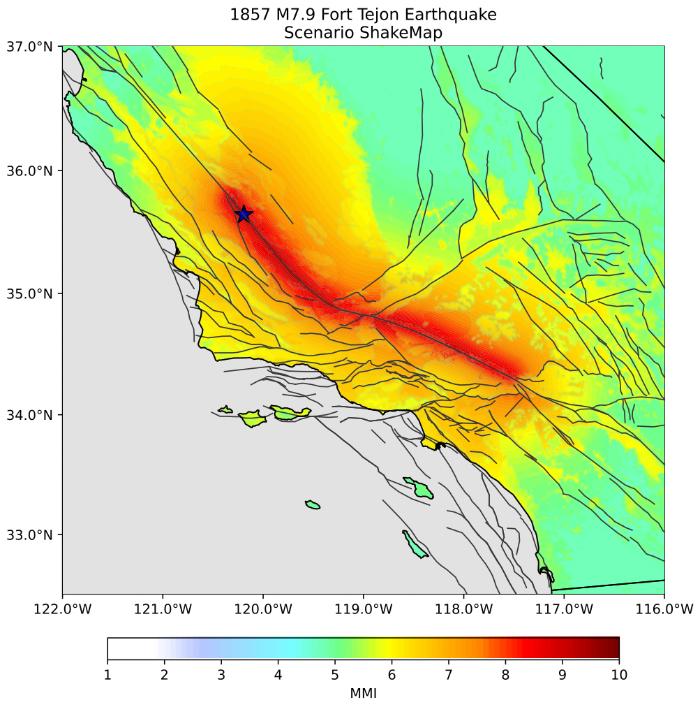
LOCATION: 35° 43' N, 120° 19' W about 72 km (45 miles) northeast of San Luis Obispo, about 120 km (75 miles) northwest of Bakersfield, as shown on the map (epicenter location uncertain).
MAGNITUDE: MW 7.9 (approx.)
LENGTH OF SURFACE RUPTURE: about 350 km (217 miles)
AVERAGE SURFACE OFFSET: about 5 meters (15 feet)
The Fort Tejon earthquake of 1857 was one of the largest earthquakes ever recorded in California, and left an amazing surface rupture scar over 350 kilometers in length along the San Andreas fault. Yet, despite the immense scale of this quake, only two people were reported killed by the effects of the shock -- a woman at Reed's Ranch near Fort Tejon was killed by the collapse of an adobe house, and an elderly man fell dead in a plaza in the Los Angeles area.
The fact that only two lives were lost was primarily due to the the nature of the quake's setting; California in 1857 was sparsely populated, especially in the regions of strongest shaking, and this fact, along with good fortune, kept the loss of life to a minimum. The effects of the quake were quite dramatic, even frightening. Were the Fort Tejon shock to happen today, the damage would easily run into billions of dollars, and the loss of life would likely be substantial, as the present day communities of Wrightwood, Palmdale, Frazier Park, and Taft (among others) all lie upon or near the 1857 rupture area.
As a result of the shaking, the current of the Kern River was turned upstream, and water ran four feet deep over its banks. The waters of Tulare Lake were thrown upon its shores, stranding fish miles from the original lake bed. The waters of the Mokelumne River were thrown upon its banks, reportedly leaving the bed dry in places. The Los Angeles River was reportedly flung out of its bed, too. Cracks appeared in the ground near San Bernadino and in the San Gabriel Valley. Some of the artesian wells in Santa Clara Valley ceased to flow, and others increased in output. New springs were formed near Santa Barbara and San Fernando. Ridges (moletracks) several meters wide and over a meter high were formed in several places. In Ventura, the mission sustained considerable damage, and part of the church tower collapsed. At Fort Tejon, where shaking was greatest, damage was severe. All around southern and central California, the strong shaking caused by the 1857 shock was reported to have lasted for at least one minute, possibly two or three!
The surface rupture caused by the quake was extensive. The San Andreas fault broke the surface continuously for at least 350 km (217 miles), with an average slip of 4.5 meters (15 feet), and a maximum displacement of about 9 meters (30 feet) (possibly greater) in the Carrizo Plain area. Kerry Sieh (1978) noted that the Elkhorn Thrust, a low-angle thrust fault near the San Andreas, may have slipped simultaneously in the 1857 quake -- an observation that a team of researchers (1996) have recently used to support the idea that future movements along the San Andreas fault zone might produce simultaneous rupture on thrust faults in and near the Los Angeles area, causing a terrible "double earthquake".
The location of the epicenter of the Fort Tejon earthquake is not known. As the name suggests, one idea is to locate it near the area of strongest reported shaking -- Fort Tejon. However, because there is evidence that foreshocks to the 1857 earthquake may have occurred in the Parkfield area, it is located on this map near the northwestern end of the surface rupture, just southeast of Parkfield, near Cholame. (Note: locating it near Fort Tejon would also have caused interference on the map between this quake's symbol and that of the 1952 Kern County quake. Hence, for both these reasons, the Cholame location was chosen.)
Below is a map of rupture of 1857 earthquake with epicenter marked by a star. The part of the San Andreas fault which exhibited surface rupture during the earthquake is shown in red.