Earthquake Information
Fault Name Index
A | B | C | D | E | F | G | H | I | J | K | L | M | N | O | P | Q | R | S | T | U | V | W | X | Y | Z
San Andreas Fault Zone
TYPE OF FAULT: right-lateral strike-slip
LENGTH: 1200 km
550 km south from Parkfield; 650km northward
NEARBY COMMUNITIES: Parkfield, Frazier Park, Palmdale, Wrightwood, San Bernardino, Banning, Indio
LAST MAJOR RUPTURE: January 9, 1857 (Mojave segment); April 18, 1906 (Northern segment)
SLIP RATE: about 20 to 35 mm per year
INTERVAL BETWEEN MAJOR RUPTURES: average of about 140 years on the Mojave segment; recurrence interval varies greatly -- from under 20 years (at Parkfield only) to over 300 years
PROBABLE MAGNITUDES: MW6.8 - 8.0
San Andreas Fault Zone -- San Gorgonio Pass Area:
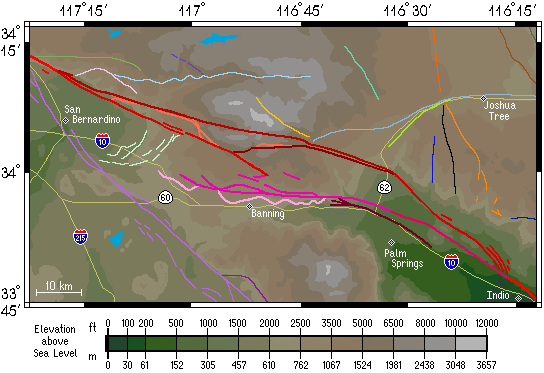
The San Gorgonio Pass area is fairly complex, geologically speaking. Here the San Andreas fault interacts with other faults (most notably the San Jacinto fault zone and the Pinto Mountain fault) and thereby becomes somewhat fractured, over the distance extending from just north of San Bernardino to just north of Indio, some 110 kilometers (70 miles). Because this deformation has been going on for well over a million years, ancient and inactive strands of the San Andreas fault can be found here. Other faults in this area are have been "reawakened" recently after being dormant for hundreds of thousands of years. There is even evidence to suggest that there is no active, continuous main trace of the San Andreas fault going all the way through the pass, not even at depth -- implying that the San Andreas fault may currently be in the process of creating a new fault path through this area! This could also mean that a single, continuous rupture from Cajon Pass to the Salton Sea (a stretch of the San Andreas that has not ruptured in historical times) is unlikely to occur. Fault rupture mechanics are still not well understood, however, and the discontinuity could prove to have little effect on tempering a major earthquake on this southern stretch of the San Andreas fault zone.
Below is a clickable map of the San Gorgonio Pass area, similar to the other clickable maps within these pages; clicking on the surface trace of a fault will take you to a file detailing some of the features of that fault. Cities and towns are shown as diamonds, lakes are shown in light blue, and highways are shown in yellow. It should be noted that due to the complexity of this area, many researchers have used different nomenclature for the local faults, and placed the dividing lines between certain named fault segments in varying places. This naturally makes it difficult to decide upon one standard for labelling maps such as this. When possible, these differences will be noted within the fault files, but keep in mind that the system used here represents only one of many ways of characterizing this intriguing and complex geologic region.
This fault is featured on the following maps:
Northwest Fault Map
Mojave Fault Map
Southern Fault Map
Los Angeles Fault Map