Earthquake Information
Chronological Earthquake Index
Kern County Earthquake
TYPE OF FAULTING: Reverse faulting, with a left-lateral component
TIME: July 21, 1952 / 4:52 am, PDT
LOCATION: 35° 00' N, 119° 02' W 37 km (23 miles) south of Bakersfield
MAGNITUDE: MW7.5
FAULT RUPTURED: White Wolf fault
MAXIMUM ELEVATION CHANGE: rise of about 1.3 meters (4 feet)
The largest earthquake in southern California since the Fort Tejon earthquake of 1857 and the Owens Valley earthquake of 1872, the Kern County earthquake of 1952 caused immense and widespread damage. The quake occurred on the White Wolf fault, a reverse fault (with some left-lateral component of slip) north of the intersection of the Garlock and San Andreas faults.
The area shaken by this quake was impressively large. It was felt in Reno, Nevada, and required a construction effort in Las Vegas to realign structural steel. In San Francisco, it was felt mainly by people on the upper floors of tall buildings. Power outtages occurred in Los Angeles, along with minor building damage. It was felt in San Diego as well, and even damaged one building there! At Owens Lake, about 200 kilometers away, the shaking broke a pipeline and disturbed salt beds, causing damage to a mining operation.
The Kern County earthquake claimed 12 lives, was responsible for at least 18 injuries, and caused at least $50 million in property damage. This quake and its aftershocks (at least 20 were of magnitude 5.0 or greater) were responsible for damaging hundreds of buildings in the Kern County area, at least 100 of which had to be torn down. It devestated a section of the Southern Pacific Railroad line near Bear Mountain. It wreaked havoc on agriculture in the Arvin area, where the land has been reclaimed from the Kern River Delta, creating conditions which amplify the shaking of an earthquake. Slumping and surface rupture caused irrigation breaks and subsurface movement disturbed well output. Major relevelling had to be done in many places.
The Kern County quake came as something of a surprise to geologists and seismologists. Not only was the White Wolf fault not previously considered a major threat, but the size of the quake seemed disproportionate to the length of the fault which ruptured. The White Wolf fault is traceable for only about 48 km (34 miles), much less than the fault length typical thought necessary to produce such a major earthquake (compare this to the nearly 400 km (250 miles) of the San Andreas fault which broke in the magnitude 8 Fort Tejon quake of 1857). The amount of displacement at the surface also seemed small for the energy released. It is possible that much of the fault is buried, leaving no surface trace. The greatest slip may have occurred well beneath the surface, so that only a meter or so of slip was seen at ground level. Deep rupture and a non-vertical fault would also provide much of the "missing" rupture needed to explain the quake's large size -- a shorter but deeper rupture on a fault with a significant dip would release as much energy as a lengthier, shallow rupture on a vertical fault, since it is rupture area, not merely length, that determines the energy released in an earthquake.
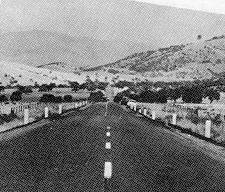
Highway 466 (currently, Highway 58), west of the Caliente-Arvin Road (currently,
Highway 223) junction, looking east. Note offset center line due to ground
breakage. (Photo: Highway Department, State of California)
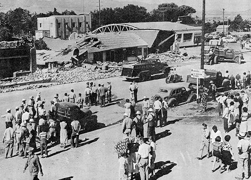
Main Street, Tehachapi, after the earthquake of July 21, 1952. The two-story
concrete (with wood floors and roof) structure in the background is the Catholic
Youth Center. Despite the fact that most of Tehachapi's business section was at
least partially destroyed, this building suffered little damage.
(Photo: World Wide Photo)
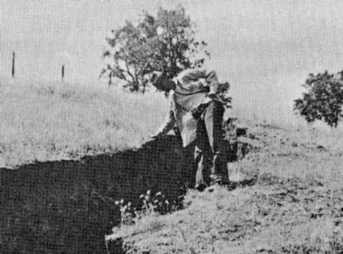
Vertical fracture on the northeast side of Bear Mountain, along the White Wolf Fault.
At this location, a vertical displacement of 60 cm (2 ft) and a horizontal (left-lateral) displacement of 45 cm (1.5 ft) were measured along the break.
(Photo: University of California, Seismographic Station)
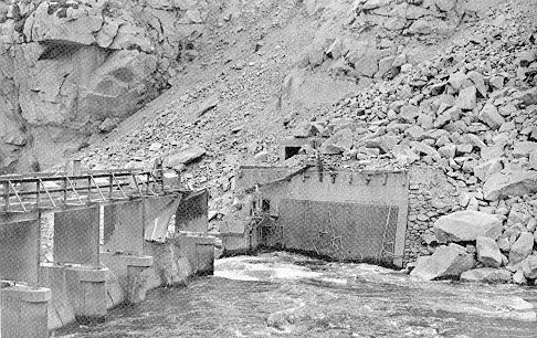
Rockslide damage to the Kern Canyon Plant Diversion Dam.
(Photo: Gordon Coltrin, Pacific Gas & Electric)
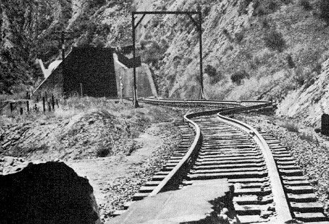
A view from the entrance of a railroad tunnel (designated "Tunnel No. 3") showing
bent rails between two tunnels near a zone of intense fracturing along the
White Wolf fault. (Photo: Southern Pacific Railroad)
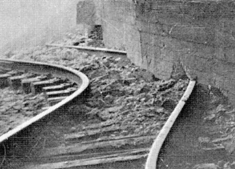
Inside Tunnel No. 3. A close-up not only of bent rails, but of an unusual
phenomenon -- the rail is continuous underneath the tunnel wall, indicating
that the wall lifted up enough for the rail to slide underneath.
(Photo: Southern Pacific Railroad )
Bakersfield Quake (Aftershock)
TIME: August 22, 1952 / 3:41 pm, PDT
LOCATION: 35° 20' N, 118° 55' W 6 miles (10 km) ESE of Bakersfield
MAGNITUDE: ML5.8
Though only about the fifth strongest of the aftershocks of the July 21 Kern County quake, the earthquake of August 22 caused a significant amount of damage for three reasons. First, of the sizable aftershocks of the July 21 quake, it was the closest to Bakersfield, the largest city in the area. Second, it occurred after at least 18 other aftershocks of magnitude 5.0 or greater had shaken the area, weakening structures over the course of a month. Third, the quake shook with a high frequency, one which targetted short, rigid buildings.
In all, two people were killed and 35 injuries were reported in the wake of this aftershock, which caused an additional $10 million worth of property damage. Most of the damage was confined to brick structures in a 64-block area of downtown Bakersfield.
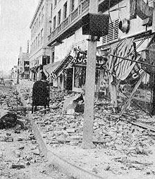
A Bakersfield street after the August 22 shock. Brick parapets fell to the sidewalk -- fortunately, the streets and sidewalks were empty at the time. (Photo: Bakersfield Police Department)
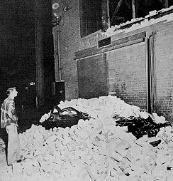
Parked cars were not spared from the falling debris, however, as some residents were distressed to discover. (Photo: San Francisco Examiner)