Earthquake Information
Fault Name Index
A | B | C | D | E | F | G | H | I | J | K | L | M | N | O | P | Q | R | S | T | U | V | W | X | Y | Z
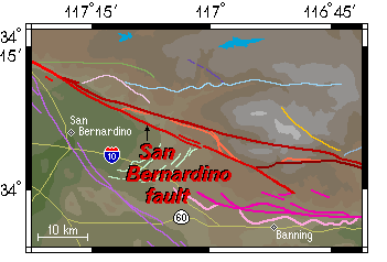
San Bernardino Fault
TYPE OF FAULTING: right-lateral strike-slip
LENGTH: 50 km
NEARBY COMMUNITIES: Highland, Forest Falls, Redlands, San Bernardino
MOST RECENT SURFACE RUPTURE: Holocene
SLIP RATE: uncertain
INTERVAL BETWEEN MAJOR RUPTURES: uncertain
OTHER NOTES: Considered to be the currently active segment of the San Andreas fault system to the northwest of San Gorgonio Pass. Forms an obvious linear scarp along the northeastern edge of the San Bernadino basin. Sometimes referred to as the South Branch San Andreas fault -- when so named, the nearby Mill Creek segment of the San Andreas fault zone is usually referred to as the North Branch San Andreas fault.
This fault is featured on the following map:
Mojave Fault Map
Southern Fault Map
San Gorgonio Pass Fault Map