Earthquake Information
Fault Name Index
A | B | C | D | E | F | G | H | I | J | K | L | M | N | O | P | Q | R | S | T | U | V | W | X | Y | Z
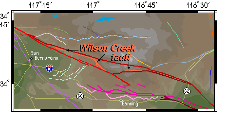
Wilson Creek Fault
TYPE OF FAULT: right-lateral strike-slip
LENGTH: all segments combined total more than 30 km; potentially active segment(s) may be much shorter
NEARBY COMMUNITIES: Highland, Forest Falls, Yucaipa
MOST RECENT SURFACE RUPTURE: mostly Quaternary to Late Quaternary in age; one strand may be Holocene in age (see below)
OTHER NOTES: As represented here, the Wilson Creek fault is made up of several sub-parallel fault traces, the longest being roughly 15 kilometers in length. Other sources may use different nomenclature.
The main trace of the San Andreas fault -- the boundary between the Pacific and North American tectonic plates -- has changed its course through San Gorgonio Pass several in the last few million years. As it has changed, it has abandoned old fault surfaces for newer ones. Possibly the oldest of these abandoned traces is that of the Wilson Creek fault. As it is mapped now, there seem to be several separate faults running sub-parallel through the terrain here. From diligent studies of the rock types these faults juxtapose, and the offsets exhibited, geologists have concluded that all these disjointed fault strands were once part of the same through-going fault, the Wilson Creek fault, which was subsequently ripped to pieces by more recent faulting. In one area, two faults run roughly parallel to each other, separated by less than a kilometer. One of these faults has its most recent rupture dated as Quaternary, and is definitely the Wilson Creek fault of old. The other shows Holocene age rupture at the surface. This may be a reactivated segment of the ancient Wilson Creek fault, though some may label it differently due to the recency of rupture.
Below is a map of the San Gorgonio Pass area. The segments of the Wilson Creek fault are labelled, and colored bright reddish-orange.
This fault is featured on the following maps:
Mojave Fault Map
Southern Fault Map
San Gorgonio Pass Fault Map