Earthquake Information
Fault Name Index
A | B | C | D | E | F | G | H | I | J | K | L | M | N | O | P | Q | R | S | T | U | V | W | X | Y | Z
Banning Fault Zone
TYPE OF FAULTING: right-lateral strike-slip, oblique right-reverse, and thrust
LENGTH: at least 40 km; inactive western segment (not shown) is inferred to extend all the way to San Bernardino
NEARBY COMMUNITIES: Calimesa, Cherry Valley, Banning, Cabazon, White Water
MOST RECENT RUPTURE: Holocene
SLIP RATE: uncertain, part of complex fault system involving the San Andreas fault zone near San Gorgonio Pass
INTERVAL BETWEEN MAJOR RUPTURES: uncertain
PROBABLE MAGNITUDES: MW6.0 - 7.2, alone; could rupture in magnitude 7 to 8 along San Andreas fault zone (?)
DIP: These faults typically dip to the north.
OTHER NOTES: Complex fault zone with long history. Interacts with or may be considered part of the San Andreas fault zone and the San Gorgonio Pass fault zone.
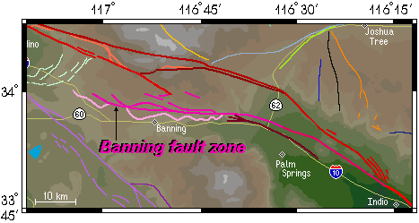
The map below shows the location of the Banning fault zone in relation to nearby structures. Some of the fault segments shown in hot pink may not technically be part of the Banning fault zone, but are grouped with it to simplify the region's nomenclature.
Remarkably enough, it has been suggested that the main Banning fault may once have been the eastern part of the San Gabriel fault, before the San Andreas and San Jacinto faults appeared in the area and severed the ancestral San Gabriel fault. The evidence for such a claim stems from the relation between the present-day Banning and San Gabriel faults with an ancient thrust fault known as the Vincent Thrust. This thrust fault appears both in the San Gabriel Mountains and the San Bernardino Mountains, near each of the supposed sections of the ancestral San Gabriel fault in such a way that suggests that, like the pieces of the Vincent Thrust, these two faults once were as one.
This fault is featured on the following maps:
Southern Fault Map
San Gorgonio Pass Fault Map