Earthquake Information
Fault Name Index
A | B | C | D | E | F | G | H | I | J | K | L | M | N | O | P | Q | R | S | T | U | V | W | X | Y | Z
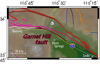
Garnet Hill Fault
TYPE OF FAULTING: right-lateral strike-slip
but evolves into oblique right-reverse at extreme western end
LENGTH: 25 km
NEAREST COMMUNITIES: White Water, North Palm Springs, Palm Springs
MOST RECENT SURFACE RUPTURES: Holocene at western end; otherwise, Late Quaternary
SLIP RATE: estimated at 10 to 20 percent of the slip rate of the Banning fault
INTERVAL BETWEEN MAJOR RUPTURES: unknown
PROBABLE MAGNITUDES: MW 6.0 - 7.0, alone; might ruputure along with nearby faults
DIP: The Garnet Hill fault dips to the north.
OTHER NOTES: Displayed ground cracking along surface trace after the 1986 North Palm Springs earthquake. This was not surface rupture, however, but was due to strong shaking.
This fault is featured on the following maps:
Southern Fault Map
San Gorgonio Pass Fault Map