Earthquake Information
Fault Name Index
A | B | C | D | E | F | G | H | I | J | K | L | M | N | O | P | Q | R | S | T | U | V | W | X | Y | Z
Sierra Madre Fault Zone
TYPE OF FAULT: reverse
LENGTH: the zone is about 55 km long; total length of main fault segments is about 75 km, with each segment measuring roughly 15 km long
NEARBY COMMUNITIES: Sunland, Altadena, Sierra Madre, Monrovia, Duarte, Glendora
MOST RECENT SURFACE RUPTURE: Holocene
SLIP RATE: between 0.36 and 4 mm/yr
INTERVAL BETWEEN SURFACE RUPTURES: several thousand years (?)
PROBABLE MAGNITUDES: MW6.0 - 7.0 (?)
OTHER NOTES: This fault zone dips to the north. It was not the fault responsible for the 1991 Sierra Madre earthquake.
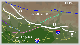
The Sierra Madre fault zone is often divided into five main segments, labelled with the letters A through E, to more easily characterize this fairly complex system. The map below shows these segments.
These five divisions, while simpler than the entire fault zone, should not be thought of as individual faults, however -- some of these segments are themselves complex systems of parallel and branching faults. It has been suggested that differing fault geometries in this zone keep each lettered segment separate during rupture events -- thus, neighboring segments should not rupture simultaneously. Others, however, suggest that the fault zone may rupture both in single-segment and multiple-segment breaks.
The most recent surface ruptures are seen on the B and D segments. The least active segment, at least in surficial appearance, is the A segment, also known as the Vasquez Creek fault, which runs between the San Gabriel fault and the intersection of the B and C segments of the Sierra Madre fault zone. At the junction of the C and D segments, the Clamshell - Sawpit Canyon fault splays off from the fault zone, toward the northeast (shown in sea green on the map above). It was this fault, not the Sierra Madre fault zone itself, that ruptured to produce the Sierra Madre earthquake of 1991 (named for the nearby community of Sierra Madre).
One of the strands that makes up segment D is known as the Duarte fault, because of its location near that community. Segment E represents the easternmost part of this fault zone, and at its eastern end, it meets up with several other faults in a complex zone northwest of the town of Upland, near the epicenter of the 1990 Upland earthquake. The general trend of the Sierra Madre fault zone continues eastward from this point along the base of the San Gabriel Mountains, but this eastern continuation is known as the Cucamonga fault zone. The Cucamonga fault zone seems to be more active (has a higher slip rate) than the Sierra Madre fault zone.
While rupture on the Sierra Madre fault zone (theoretically) could be limited to one segment at a time, it has recently been suggested that a large event on the San Andreas fault to the north (like that of 1857) could cause simultaneous rupture on reverse faults south of the San Gabriel Mountains -- the Sierra Madre fault zone being a prime example of such. Whether this could rupture multiple Sierra Madre fault zone segments simultaneously is unknown.
This fault is featured on the following maps:
Mojave Fault Map
Southern Fault Map
Los Angeles Fault Map